More about HKUST

Translations

Translation goes beyond transforming languages; it involves the transference of messages across various mediums, including text, visuals, and even gestures.

In this zone, visitors can observe different examples of geographic knowledge being transferred and transposed across various media. Some originated as text and were later visualized as maps, while one Chinese map was "translated" into its English version in all aspects except the language itself. Ancient stories and folklore about faraway lands may be represented on maps in the form of reinterpreted text or images, exemplified by some of the exhibits.

This conversion across media was an essential dynamic in the history of mapmaking, inviting visitors to reflect on the interpretation and reinterpretation of messages across time, languages, and forms.

<i>Xvntien alias Qvinzay</i><br>[Xuntien, also known as Quinzay]

Xvntien alias Qvinzay
[Xuntien, also known as Quinzay]

Amsterdam, c. 1657
Jan JANSSON (1588-1664)
42 x 52 cm
HKUST Library G7824.H3A3 1657 .J35


This painting is supposed to depict the city of Hangzhou, showcasing its buildings, canals, bridges, and surrounding junks. The city plan is based on Marco Polo’s description of Hangzhou in the late 12th century, which highlights its 12,000 bridges, extensive network of canals, paved roads, and large lake with island pavilions and palaces. However, Jansson, the mapmaker, reproduced this information with fanciful embellishment in European style. Interestingly, this is the only city of the Far East to appear in Jansson's Theatrum Urbium Celebriorum (Amsterdam, 1657)

<i>Tabula Svperioris Indiae et Tartariæ Maioris</i><br>[A Map of Upper India and Greater Tartary]
Tabula Svperioris Indiae et Tartariæ Maioris
[A Map of Upper India and Greater Tartary]

Lyon, 1535
Lorenz Fries (c. 1490-1550)
29 x 46 cm
HKUST Library G7400 1522 .F68


This woodblock map is one of the earliest printed maps of Asia, it covers the regions of China, India, and Japan. It was originally engraved for Lorenz Fries' atlas, "Opus Geographiae", in 1522, and was later reissued in subsequent editions of 1535. The map draws information from a variety of sources, including the accounts of Marco Polo, as well as contemporary European sources.

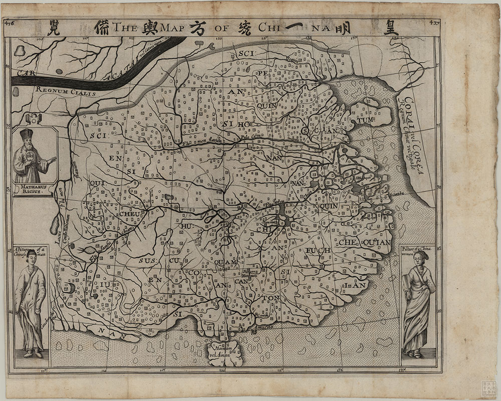
The Map of China

The Map of China

London, c. 1625-1626
Samuel PURCHAS (c.1575-1626)
30 x 37 cm
HKUST Library G7820 1625 .P87


This map appeared in a 1625 book by English travel writer Samuel Purchas (c. 1577-1626). It is in fact a copy of a Chinese map, which was obtained by an English merchant in Java. When we compare the map with the original, which has one extant copy in Poland, we can see that the English printer could only reproduce the Chinese title, but failed to copy or translate place names, resulting in many empty rectangles on the map.

<i>China Regnum</i><br>[The Kingdom of China]

China Regnum
[The Kingdom of China]

Antwerp, 1593
Cornelis de JODE (1568-1600)
36 x 45 cm
HKUST Library G7820 1593 .J64


The map has a unique design that appears as a central circle, showing China, Northeast Asia, parts of western Japan, including Kyushu, Shikoku, and most of mainland Honshu. It is the first European map to show the emerging shape of the Korean peninsula and Bohai (labelled as Gulf of Pecheli). The ornate strap-work border includes four round insets depicting European interpretations of Chinese and Japanese scenes, providing some of the earliest Western illustrations of Chinese and Japanese life.