


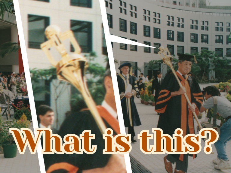
If you have ever been to one of the congregation ceremonies at HKUST, you might be wondering ─ what is that long stick the procession leader is carrying? A staff of some sort, perhaps, but what is it for? Despite its unconventional appearance, this is the University’s ceremonial mace. Most universities have a ceremonial mace displayed on formal occasions like congregations, and HKUST is no exception. Ours is unique in two ways. It is longer than traditional ceremonial maces, measuring over 1.5 meters and weighing in at over 15 kg (35 pounds) ─ as heavy as a small child! And it sports a sleek and modern design that features our university’s emblem, much unlike the ornate designs used by monarchies or other older universities. Left: A close highlight of the HKUST mace, HKUST Library Right: Chancellor’s mace, figure of Louis XIV, of Saint-Louis at the Palais du Tau, G. Garitan, CC BY-SA 3.0, via Wikimedia Commons Where did maces come from? Why do they appear in university ceremonies?

Are you a nostalgic person? Will you long for the chance to visit a place you stayed in before again? To me, HKUST library is the place I would never feel bored visiting again and again. As a patron… I am a HKUST 2017 alumnus with a Bachelor of Science degree in Physics. But before taking the 4-year bachelor’s degree, I have already been to the library and experienced the beauty of the 5-storey building. If you are familiar with HKUST Library history, you may know that the library was actually open to the public before 2016 – there were no entry gates! So before I was an official university student, I had already ‘sneaked' into the library on the UST Open Day. I remembered the amazement I had when I found out the shelves in LG3 and LG4 were actually movable. The enormous size of the building, and the view you have when you are walking along the staircases, were certainly stunning and to be honest, UST library was one of the reasons why I chose HKUST to have my tertiary education. As a worker… Starting this winter, my relationship with UST library has changed from a visitor to a staff member.
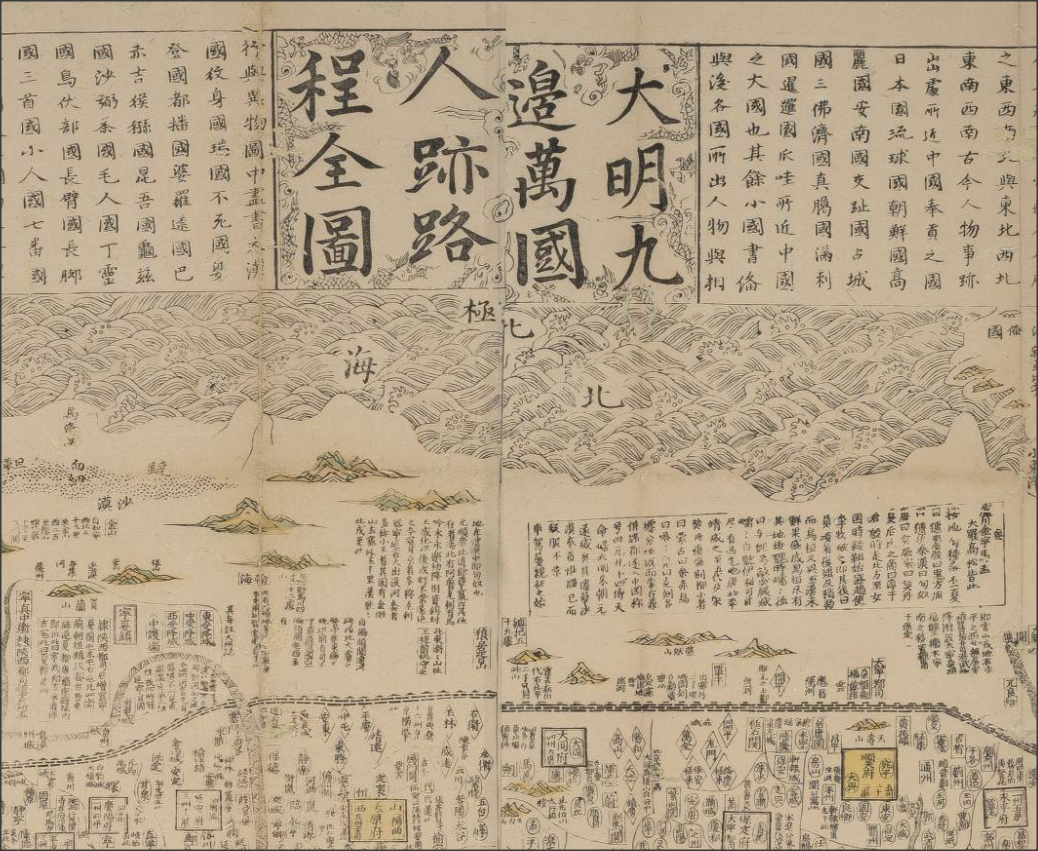
Old maps are visually beautiful; and they carry a lot of interesting stories. The Library hosted a 3-day research symposium last December with map historians from local and overseas institutions. One really memorable talk in the symposium was about this famous Chinese map dated 1644, the year the Ming Empire collapsed: <天下九邊分野人跡路程全圖> (A comprehensive map of the kingdom of China and neighbouring countries). The speaker, Professor Mario Cams of KU Leuven (Belgium), explained that this fascinating map was a hybrid of Chinese and European mapmaking; he told the interesting threads of history in a century of east-west exchanges that led to this map. We do not have a copy of this rare map, but you can find a similar one printed in the 18th Century in our Special Collections. You can examine the image of the 1644 map at this site: look for the latitude scale, north and south poles, Europe, North and South Americas (separated); these are the typographical knowledge from the West, and are scattered around the edges of the map. However, the bulk of the map in the middle is the Ming Empire administration, which is not intended to represent geographical reality. To weave the story of the map, Professor Cams started in 1555, the era when 2 Chinese maps from Fujian travelled to Europe via merchants in Southeast Asia. Afterwards, Jesuit missionaries brought European geographic knowledge to the East, forming the basis of this "hybrid map". An important thread in the story is the Ming book publishing culture.
