


Back to Events
#Historical Cartography
Library iTalks
Library iTalks
10
16
17
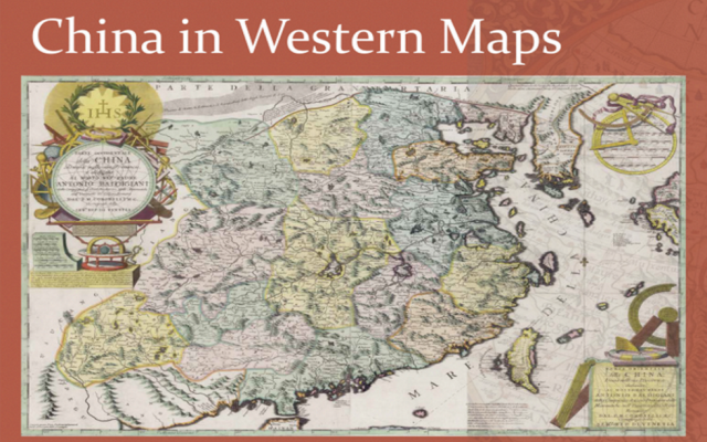
About the TalkBased on the first comprehensive study of all Western printed maps of China until 1735 (https://brill.com/view/title/39120?language=en), this talk will first show how to look at old maps using examples of the HKUST rich map collection, then will explain how Europeans maps of China changed over time and what they can teach us about the history of Europe and China and their entangled relationship. It will also tell some of the unique stories that made possible these visions from another world, stories marked by scholarly breakthroughs, obsession, missionary zeal, commercial sagacity and greed.Date: October 13, 2022
Time: 15:30 - 16:30
Venue: Kaisa Group Lecture Theater (IAS LT), Lo Ka Chung Building, Lee Shau Kee Campus, HKUST (Direction)
Registration: https://lbcube.hkust.edu.hk/ce/event/9069 Speakers BioMarco Caboara is the Manager (Digital Scholarship and Archives) at the Lee Shau Kee Library, The Hong Kong University of Science and Technology. As manager of the Archives he is also in charge of the Library Special Collections, most prominently of the Antique Maps of China Collection. He studied in Italy, the Netherlands, Taiwan, Beijing and Hong Kong, and received his Ph.D. from the University of Washington, Seattle with a study of the linguistic features of Classical Chinese Bamboo Manuscripts. He has been a Research Fellow at Friedrich-Alexander-Universität Erlangen-Nürnberg and the Swedish Collegium for Advanced Studies, Uppsala, Sweden.He has just completed a comprehensive carto-bibliography of Western printed maps of China from 1580 to 1735, published by Brill and has presented the earliest stages of the book project at major international map conferences in Amsterdam, Berlin, Macau and Shanghai.
Details
2022-10-13
Kaisa Group Lecture Theater (IAS LT), Lo Ka Chung Building
Library iTalks
Library iTalks
11
16
17
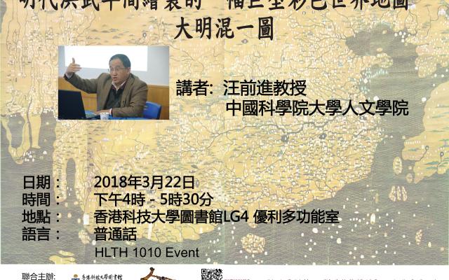
研討會簡介於鄭和之先:東亞最早的世界地圖 ──《大明混一圖》一幅珍貴而外界很少有人知曉的世界地圖──《大明混一圖》,約繪於明初洪武二十二年(1389年),三米見方的舊大陸地圖,東至日本、西至西歐和西非、北至西伯利亞、南至爪哇,較鄭和下西洋更早,現藏於北京中國第一歷史檔案館。中國古代地圖專家汪前進教授,將為我們解說《大明混一圖》的歷史地位和學術意義。名額有限,請報名留座
備註: 出席此座談會的同學可獲HLTH1010課程中"Activities"單元的"Wellness and Personal Enrichment"1.5小時學習時數。講者簡介汪教授現職中國科學院大學人文學院,曾任中國科學院自然科學史研究所研究員;他的學術範疇涵蓋中國地圖學史、中國地理學史、中外科技交流史等,對中國古地圖研究甚深。
備註: 出席此座談會的同學可獲HLTH1010課程中"Activities"單元的"Wellness and Personal Enrichment"1.5小時學習時數。講者簡介汪教授現職中國科學院大學人文學院,曾任中國科學院自然科學史研究所研究員;他的學術範疇涵蓋中國地圖學史、中國地理學史、中外科技交流史等,對中國古地圖研究甚深。
Details
2018-03-22
Library LG4 Multi-Function Room
